Uncategorized
Nazca Lines
Jun
NAZCA LINES
The Nazca Lines are a collection of huge drawings etched on the desert surface of the Nazca region.
On this desert plateau, we can find large figures representing various types of geometric forms and human beings.
We can classify the Nazca Lines into five types.
The most well-known are the straight lines, geometric shapes, and animals, insects, and plant drawings.
The others are figures in high relief, and the so-called unknown stars, which are less popular, but nonetheless spectacular.
All the images are so large, that the best way to fully appreciate them is only from the air.
To this day no one has been able to fully explain the meaning of the Nazca lines.
Its real purpose continues to puzzle archaeologists around the world.
Since their discovery in the 1920s, emerged many theories, but their significance remains largely shrouded in mystery.
Due to its monumental size and unique art, they were designated by UNESCO as a World Heritage Site in 1994.
INTRODUCTION
According to archaeologists, the Nazca Lines were constructed between 200 B.C. and 600 A.D.
Their creation is attributed to the ancient Paracas and Nazca people, who flourished on the southern Peruvian coast.
Scholars believe the Nazca culture would be a continuity of the Paracas people, as both cultures reflect similar customs.
The Paracas culture declined around 200 BC, eventually disappearing, allowing the rise of the Nazca culture.
NAZCA LINES LOCATION
The Nazca Lines are located in the Nazca Desert, a barren plateau in southern Peru, approximately 400 kilometers south of Lima.
Specifically, they are found in the Pampas de Jumana and San Jose, a vast arid plain between the towns of Nazca and Palpa.
THE ORIGEN OF THE NAZCA LINES
The Nazca lines find their roots in the Paracas Culture, which thrived around 500 BC in the southern valleys of Peru.
During this time, the Paracas people utilized the vast flat surfaces of large rocks as their canvas, giving birth to what we now refer to as petroglyphs.
These petroglyphs are abundant in these southern valleys, showcasing images depicting animals, plants, deities, and various other forms.
During the later stages of the Paracas Culture, a notable transition took place, marked by their adoption of larger-scale depictions primarily focused on anthropomorphic figures.
In contrast to the Nazca lines, the Paracas images were etched onto hillsides, allowing the villages below to see their creation.
These remarkable images provides evidence that ancient cultures predating the Nazca civilization were already engaging in the creation of geoglyphs nearly 500 years before the Nazcans.
The Nazca lines, therefore, emerged as an extension of this rich artistic tradition initiated by the Paracas culture.
It is within this cultural context that the Nazca Lines came into being, capturing the imagination of generations to come.
While the Paracas people primarily expressed their artistry on rocks, the Nazca civilization took it a step further by creating immense geoglyphs on the desert floor, visible from a bird’s eye view.
WHO WERE THE NAZCANS
The Nazcans were a tribe that settled in the coastal desert of southern Peru, having as its capital the city of Cahuachi.
Cahuachi was a large religious center built with mudbricks, covering in its heydays over 24 square kilometers.
Its pyramids, temples, plazas, and terraces once received hundreds of pilgrims from the nearby valleys.
Besides the bizarre figures etched on the desert, the Nazcans achieved their reputation for the elaboration of colorful pottery.
Their pottery were made for domestic use and while the other finely elaborated, were made for social and religious purposes.
The vessels reflected their daily life, their gods, flora, and fauna, and also show some of the same figures that appear in the Nasca desert.
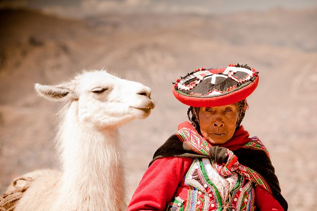
They were also exceptional craftspeople that produced wonderful textiles made from camelid wool and plant fibers.
The Nazcans based their economy on agriculture, and to be successful they developed a system of underground aqueducts to irrigate dry lands that lacked surface water.
Thus, they were able to combat the ever-growing dessert around them.
Incredibly, these ancient channels are still in use today by local farmers.
Since the Nazcans lived relatively close to the ocean, fishing might have been an important activity and probably a good source of trade with Andean merchants.
Scholars believe the Nazca people were skilled fishermen, proof of that can be certainly seen in the iconography of their pottery and textiles, where they depicted not only sea creatures but also fishing tools and rustic boats.
THE NAZCA ENVIRONMENT
The Nasca region is one of the driest places on our planet, bounded by the Andes on the east and the Pacific Ocean on the west.
Despite Peru’s tropical location, the coast of Peru is virtually a long desert strip, that goes for over 2,500 km.
The desert is generated by the icy Humboldt current in the Pacific Ocean and the prevailing winds, both running from south to north.
The cold Humboldt current prevents evaporation at the sea, and eventually the formation of clouds, and as a result, it rarely rains in these regions.
On the other hand, the eastern slopes of the high Andes, block the rain clouds coming from the Amazon Rainforest, therefore the coast of Peru does not receive rainclouds coming from that side.
Nonetheless, every year, during summer time, (December, January, February, and March), the water in the Pacific gets a little warm.
This rise in the temperature of the water generates rain clouds, which are usually blown by the winds towards the Andes, where precipitation occurs.
As a result, the rivers fill with this precious element, which later flows down towards the Pacific Ocean, creating fertile valleys along the Peruvian coast.
Occasionally, every 7 or 10 years, the Peruvian coast experience a natural phenomenon known as El Niño, which is mainly associated with natural disasters.
When El Niño occurs, the water in the ocean gets warmer than usual, air pressure increases, trade winds change directions, and precipitation level rises, causing severe storms and heavy rains.
Archeological investigations also suggest that the Nazca region also experienced serious drought due to another phenomenon known as La Niña.
In addition, an oceanic tectonic plate located in front of the Nazca zone, generates tremors and earthquakes, causing from time to time serious damage to the region, and even killing its inhabitants.
During archaeological excavations, various corpses have been found under fallen walls inside ancient settlements, indicating the existence of this natural phenomenon in the past.
THE NAZCA LINES DESERT
The Nazca Lines desert is a large tableland covered by pebbles and small rocks.
This desert plateau is situated at 430 meters above sea level. (Longitude: -75.130005 & Latitude: -14.739027)
The region is extremely rich in iron, therefore, the dark color of the soil is the result of the oxidation of this mineral.
In some areas the Nazca desert turns reddish, this is due to the contact between the rocky surface and the morning dew.
The iron rocks have oxidized over time, creating a sort of gigantic blackboard, so dark and mysterious that resembles the surface of the moon.
Nonetheless, a few centimeters below, the ground contains clay soil and gypsum sediment, the mix creates a white color and in some areas a yellowish tone.
THE NAZCA LINES CONSTRUCTION
Most researchers agree that the Nazca people made the drawings on the desert by clearing away the dark stones on the surface to expose the gypsum ground beneath, creating this way a high contrast between the dark surface and the light furrows.
Consequently, to create a large drawing the Nazcans only had to remove the stones on the surface, piling them along the edges, following the pattern they wanted.
The drawings should have been first sketched on a small piece of textile, to later scale up the image of the desert, using probably measurement units, that are unknown to us.
Archaeologists believe the Nazcans used wooden stakes for the construction of the lines, as remains of stakes have been found at the end of some lines,
The Nazcans might have put stakes in the ground and tied a rope between them, and then remove the stones along the rope to create straight lines.
As to the large geometric forms, such as the huge rectangles, we believe that they simply marked the borders and then remove all the pebbles on the interior, pilling them up along the edges, creating this way a huge clear zone.
Amazingly, these enigmatic drawings have lasted in this desert for over 2,000 years. How can we explain such remarkable conservation?
PRESERVATION OF THE LINES
Some facts have contributed to the preservation of the lines, being mainly the sun rays, dry climate, and moisture.
We need to bear in mind, that the area was left untouched for over 1000 years, and due to its location and above all, its dryness, nobody has ever farmed these deserts.
Furthermore, we need to take into account, the nature of the soil, which is made up of clay and gypsum.
The humid winter nights and the morning dew, make the stones sink gradually into the ground.
During the day, the sun hardens the surface, leaving the stones even more securely fixed in the soil.
Therefore, we might say, that thanks to this natural combination of water, gypsum, and solar heat, the surface of this desert turned compact.
Throughout the year the zone receives constant winds, but these natural elements are not strong enough to move the stones.
Additionally, most of the Nazca drawings were made on strategic areas or high plateaus, to avoid their destruction from natural forces, such as El Niño, which usually appeared with heavy rains and considerable flash floods.
In the past, the floods caused by El Niño left behind large footprints, such as dry river beds and many lines partially cut or destroyed. All this can be seen when we fly over the zone.
NAZCA LINES DESIGNS
In contrast to the famous geoglyphs of the Nasca culture, which are found mostly on the flat plateaus between the valleys, the Paracas were generally etched on the slopes of the hills; in this way, they are visible from the terrain itself or the valley bottoms. With extensions between 2 to 30 meters, they are smaller than the Nasca.
Among the motifs represented by the Paracas culture in the zone of Palpa, we can find zoomorphic figures, especially birds and cats, as well as anthropomorphic figures.
Moving north towards the Nazca plateau, we can find hundreds of straight lines, that crisscross the desert forming a giant maze.
Other designs are geometric shapes, such as triangles, spirals, and trapezoids, which were mostly created on a larger scale.
Regarding animals, we can find various types, such as birds, quadrupeds, marine creatures, insects, and plants.
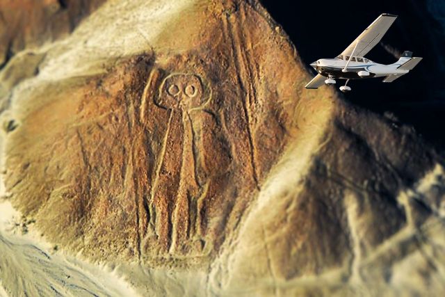
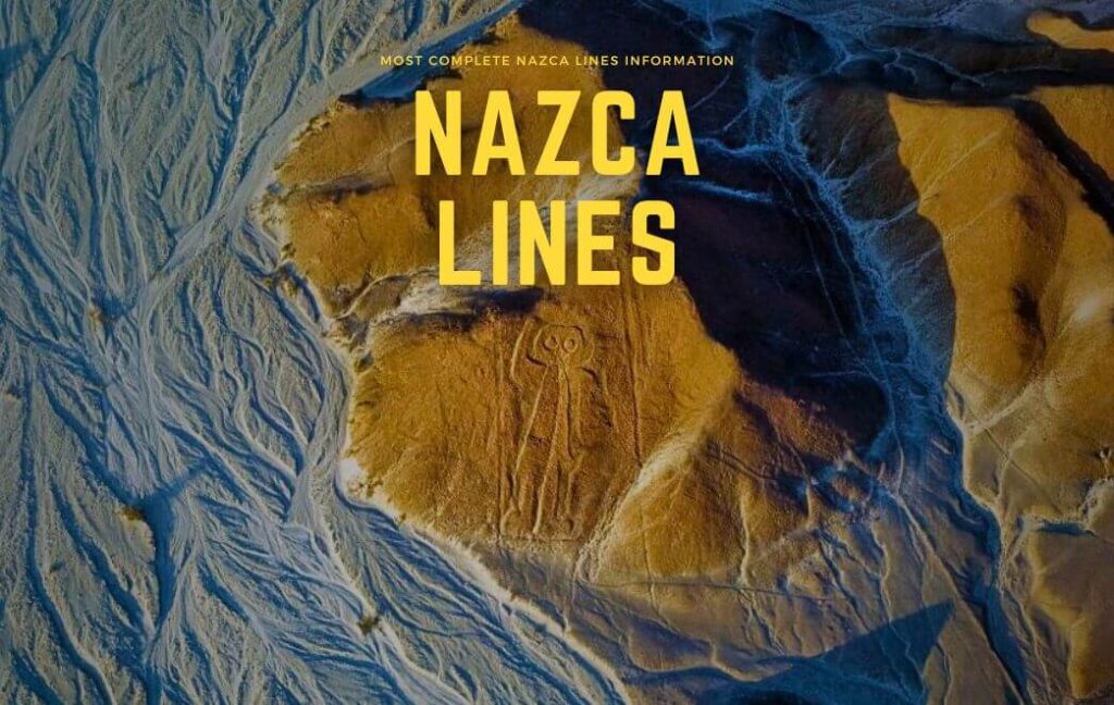
As to the human figures, there are various drawings, among them, stands out a human outline known as the Astronaut.
It is important to point out that most of the human figures were etched on hillsides rather than the flat floor, and were created in early times.
There are also still many other figures that are yet unidentified.
The size of the figures can be huge, many of them at least the size of a football field.
The largest figure found in the Nazca desert is a bird, known today as The Heron, which covers 300 meters in length, about 3 soccer fields.
On the entire archaeological complex exist more than 800 straight lines, some of which are over 40 kilometers long.
NAZCA LINES DISCOVERY
The Nazca Lines remained unknown to the world for over 1000 years, thanks to their gigantic sizes and isolated location, they lay hidden from the human eyes.
It was not until the 1920S, that airline pilots flew over the zone and spotted various straight lines.
Shortly afterward, the news about these desert lines spread around the country, and soon the desert would receive its first visitor.
In 1926 Archaeologist TORIBIO MEJIA XESSPE arrived in Nazca, following the report of recent strange findings in the desert of Nazca.
After exploring the valley and observing some straight lines in the arid desert, he got to the conclusion, that the lines he saw were Ancient Sacred Roads.
Unfortunately, the reports made by Mejia Xesspe did not attract the attention of the public in those years.
In 1939, Professor PAUL KOSOK from Long Island University of Brooklyn arrived in the Nazca desert, driven by his interest in ancient irrigation systems that existed in the Nazca region.
During his exploration across the Nazca Valley, He would stumble upon the existence of the Nazca Lines.
In the beginning, he thought the lines on the desert could be also part of the ancient irrigation system, however, soon he would realize, he was wrong.
It is said, the first time Kosok visited the Nazca desert, he happened to be standing on a hilltop at the center of a group of lines, just as the sun began to set.
Looking along one of the lines, he realized that the Sun was setting directly above it.
He was shocked by this, for the date was June 21st, the shortest day of the year in the Southern Hemisphere (Winter Solstice).
Thus, he would declare later on that the ancient Nazcans had constructed this line to mark the winter solstice.
To explore the vast lifeless desert, Kosok hires the service of an airplane to observe the zone of lines from above.
It was at this moment when Paul Kosok saw for the first time hundreds of straight lines, enormous geometric shapes, and animal drawings.
After mapping the desert, he declared that the Nazca Lines were part of a giant astronomical calendar, telling ancient Peruvian when to plant, irrigate and harvest their crops.
NAZCA LINES THEORIES
MARIA REICHE
Maria Reiche was a mathematician, who escaped from Nazi Germany to Peru in 1932.
She dedicated her life to the drawings of the Nazca desert, almost continuously from 1946 until she died in 1998.
She continued the investigation of Professor Paul Kosok, whom she met in 1940 while living in the city of Lima.
Maria Reiche arrived in the city of Nazca for the first time on December 17th, 1941, just a few days before the summer solstice take.
She spent the night in the hotel of Nasca, in the hotel “Royal”, today on the third block of Lima Street.
The first figure she discovered was the spider in June 1946. She discovered the figure of the SPIDER and sent the photos to Dr. Kosok.
He had the photos reprinted and copyrighted in various magazines, but never got in touch again.
During this year, Maria Reiche received a donation from the local mayor of Nazca, Don Agustín Bocanegra y Prada. The mayor gave her an old truck and a scissor ladder.
Thus, she could drive to the desert, before the sun rises to take the first photos of the Nazca plateau.
Since the city of Nazca was a bit far from the, she found a new place to leave in La Pascana, a small village very close to the desert drawings.
In 1947, Maria Reiche took the first aerial photographs, flying over the zones of Ingenio and Nasca. She flew over the lines thanks to a local pilot who used his small plane to spray agricultural lands.
In 1948, she discovered the HERON figure, a large bird of 300 meters in length, which she associated with the winter solstice.
On June 21st, (winter solstice in the southern hemisphere) she noticed that the beak of the heron was pointing toward the sunrise, thus this observation makes her believe the heron was announcing the beginning of winter.
In 1952, she discovered the MONKEY figure, a particular drawing that was drawn just with nine fingers, just like Maria, who also had nine fingers.
Reiche spent years carefully measuring the lines and plotting the relationship to the movements of the sun, moon, and stars.
She concluded the geometric line was a giant astronomical calendar. The whole complex, according to her theory, was designed to help organize planting and harvesting.
She also thought that ancient Peruvians constructed the drawings to please the gods and secure their goodwill.
She believes all images were symbols to remind the gods that their lands were dry and needed water and that crops needed blessings.
Unfortunately, the Pan-American highway, which was built in 1938, crossed the Nazca desert, destroying in its path many of the lines and designs.
Among the destroyed drawings is the lizard, whose body was cut in two when the road was constructed.
Her tireless efforts paid off, and eventually, she managed to get the Government of Peru to restrict access to the area and build an observation tower next to the highway to facilitate the vision of the lines without invading them.
Before the Pan-American was built, the population used drove randomly over the figures, as the drawings were so large, and they could not see them from ground level.
Besides her efforts to decipher the lines and her tireless struggle to protect the site, Reiche’s biggest contribution was putting the lines on the map.
Although her theory fell out of fashion, Peruvians felt immense gratitude and affection towards the woman they call today “The lady of the desert”.
GERALD HAWKINS
Astronomer Gerald Hawkins was already well known among scientists when he began his research on the Nazca Lines in 1967.
After exploring Stonehenge in England with successful results, Hawkins decided to use the same technological tools he used for Stonehenge to solve the mystery of the Nazca Lines.
Thus, he and his colleagues came to Nazca to test the astronomical theory of Maria Reiche, but once more, the astronomical proposal could not be proven.
In 1968, an investigation carried out by Hawkins and the National Geographic established that, while some of the Nazca lines did point to the positions of the Sun, Moon, and certain stars 2000 years ago, it was nothing more than mere chance.
He came back to Nazca in 1973, and surveyed 186 lines with a computer program and found that only 20% had astronomical orientation, once more, it was understood as pure chance.
Hawkins could find no correlation at all between the lines and the cosmos, therefore from his point of view, astronomy was not the solution to the puzzle.
Following Hawkins’s research, eclipsologist Robin Edgar believes that the Nazca drawings, main animals, might be an ancient response to the so-called “Eye of God”, which is manifested in the sky during a total solar eclipse.
Robin Edgar asserts that there were an unusual series of total solar eclipses over southern Peru in Nazca times, which potentially coincided with the construction time of the drawings.
He says that when the sun is eclipsed, it looks like the pupil and iris of a gigantic eye up in the sky.
So, he believes the drawings were created to be seen by the so-called “eye of god” during a total solar eclipse.
ERICH VON DANIKEN
In 1968, Swiss writer, Erich von Daniken, fueled a wild scientific debate, on his book “Chariots of the Gods”, he declared the Nazcans were communicating with visitors from other planets.
According to his theory, the huge geometric forms were made by Aliens when they landed on the Nazca desert a long time ago.
He believes that when the Alien’s machines landed on the Nazca desert, stones were blown away by the power of their rocket propulsions, making a big track on the ground, and after some time, when the Aliens left, the Nazcans came to the site and saw these huge tracks, landing tracks and take off tracks, so they would whisper, the fiery gods, rolled on these lines.
JIM WOODMAN & JULIAN NOTT
In 1975, adventure Jim Woodman and balloonist Julian Nott visited the Nazca desert.
They didn´t have only a different theory but also did their best to prove it.
Both adventurers were convinced the Nazcans had flown over the desert in a hot air balloon to look at the drawings while worshipping the sun.
So, they tried to prove the Nazcans could fly, by building a hot air balloon, using materials the ancient Nazcans would have had.
They used a reed boat as a gondola and cotton cloth for the envelope, the funnel was heated from a fire pit, so finally, they lifted off, flying over the desert only for 2 minutes.
The deeper investigation established that there is no evidence that the Nazcans could have built a hot air balloon or were able to fly.
PHYLLIS PITLUGA
Phyllis Pitluga a teacher from the Adler Planetarium in Chicago, visit Nazca for the first time in 1983, interested in Inca Astronomy.
Years later, she would be invited by Maria Reiche to join her on the investigation of the Nazca Lines, taking into account her experience and knowledge about the cosmos.
Initially, she supported the theory of Maria Reiche, believing the origin of the lines was connected with celestial bodies and it might have been used as an astronomical calendar.
After a painstaking survey work in the desert, Pitluga got to the conclusion that the lines did not match with the constellations in the Nazca sky.
As to the lines, she believes that it a was mere coincidence that some lines were pointing to certain important stars, as there are millions of stars in the sky, and any line could be pointing at anything just because of the profusion.
ANTHONY AVENI
In the 80s, Anthony Aveni, a professor of astronomy and anthropology at Colgate University in New York, began a new research on the Nazca desert.
To test the astronomical theory, Aveni put Nazca Lines date through a computer and did not find a significant match between lines and important stars.
On the contrary, he asserts that the lines and trapezoids are related to water … but not used to find water, but rather used in connection with rituals.
He believes that some of the lines were sacred pathways meant to be walked in rituals where the Nazcans probably beg their gods for rain.
He also indicates that a significant number of lines are pointing toward the foothill of the Andes, where the sun used to rise at the beginning of the rainy season, suggesting that perhaps, those lines were created to worship deities, particularly those related to rain.
Aveni noticed that a significant number of straight lines converged in spoke patterns that he calls “ray centers.”
After months of subsequent fieldwork, Aveni identified at least 62 ray centers and some 800 straight lines. Almost every line connects to a ray center and virtually every ray center occurs on a hilltop.
The lines were sacred paths that led Nazca clans and priests to the ray centers and nearby trapezoids where ceremonies related to water were carried out.
PERSIS CLARKSON
Canadian archaeologist Persis Clarkson focused on studying geoglyphs in the Americas, particularly in areas ranging from US to southern Peru and northern Chile.
In the 1980s, she joined a project led by Aveni, conducting a detailed survey of cultural remains on the Nasca pampa.
She documented various features like stone circles, cairns, and artifacts, aiming to understand the cultural and environmental context of the geoglyphs.
Her own subsequent projects continued this research.
She investigated the timeline of the geoglyphs, initially suggesting that biomorphic figures were from Nasca times while lineal geoglyphs belonged to later periods, leading to debates.
Through further fieldwork and dating, Clarkson revised her view, proposing that certain lineal geoglyphs might also date back to Nasca times.
She emphasized the function of the geoglyphs as pathways, potentially used for rituals or everyday activities, supported by footpaths and artifacts nearby.
Clarkson connected stone circles and simple pottery with the people who built the geoglyphs.
She suggested that they intentionally broke delicate pottery in rituals.
Clarkson’s research made people notice forgotten things connected to geoglyphs.
Her studies helped us understand more about the culture around the geoglyphs.
She was among the first to try and find out how old the geoglyphs are using different methods of dating.
HELAINE SILVERMAN
Helaine Silverman, an American archaeologist, extensively researched the Nasca region in the 1980s.
She focused on two main projects: excavations in Cahuachi and a settlement survey of the Ingenio valley.
Her work differed from previous researchers in that she didn’t isolate the Nasca geoglyphs but saw them as part of a broader cultural context.
Silverman found that geoglyphs were often near settlements, pointing to them or connecting them.
She believed the geoglyphs were linked to the spiritual, ritual, and social center of Cahuachi.
She thought the lines on the pampa were like pathways for pilgrims going to Cahuachi and spaces for gatherings and rituals of social groups.
Like Urton, she thought Nasca society was organized in a dualistic way.
Silverman’s idea was that the Nasca drainage area was divided into two parts, and the pampa was a place where people from these parts met and interacted. She suggested that Cahuachi and another site called Ventilla, were connected by a geoglyph, strengthening the idea of the pampa as a common ground.
However, some doubts arise from her theory.
The supposed geoglyph connecting the sites was destroyed by the old Pan American road, called by locals CAMINO DE LEGUIA in the 1920s, so it’s unclear if it ever existed.
Also, Ventilla hasn’t been well studied, and there are questions about Cahuachi’s role as she proposed it.
Silverman believed the geoglyphs were part of a larger ritual complex, involving predictions about water, sky observations, and worship.
She thought the lines were like a record of important information for social life.
In short, Silverman’s view is that the geoglyphs were part of a bigger picture involving rituals, predictions, and cultural practices.
However, her model lacks strong archaeological proof to support its specific details.
GARY URTON
In 1990, Gary Urton, an American researcher, studied how people act together and perform rituals in modern communities in Peru.
He looked at old stories and records to learn about these behaviors and their history.
He joined another researcher named Aveni to study the Nasca lines, big shapes in the ground in Peru.
Urton learned from the stories and records that people from the past used to work together during special times, like religious events, to take care of important things in their community.
Urton found that a long time ago, the Nasca society had different levels of groups.
There were small groups of people with shared rights to land, called “ayllus.”
These small groups came together to form bigger groups, and these bigger groups were part of even larger groups.
Urton saw that this pattern was like building blocks.
Urton believed that the ways people organized themselves and the land back then are similar to how they did things later in time.
He thought that the lines were taken care of by people working together in these groups.
They might have also done special rituals like cleaning sacred places before events.
Even though Urton didn’t find direct proof about the lines themselves, he made a clear idea about how the people might have lived during the time of the lines.
He also agreed with other researchers that the lines probably had something to do with rituals, even if not just that.
DAVID JOHNSON
David Johnson, a smart geology expert from New York, visited Nazca in 1995.
He’s good at finding water underground and got curious about Nazca because it didn’t have much water for farming.
He liked challenges like this. He explored the dry Nazca Valley and talked to local farmers to learn about their water problems.
David began by studying old channels in the ground called Nazca Puquios.
These were made by ancient Nazca people around 500 AD.
While he looked at these channels, he saw other marks in the ground nearby (Nazca Lines).
He thought these lines might show where water was hidden underground.
He guessed that the old Nazca people knew about the land and built their homes where they could find water.
David’s idea is that there are rivers under the desert and the Nazca drawings show them.
He thinks shapes like trapezoids mean there’s water below. Spirals show which way the water flows.
Big triangles point to cracks in the earth where water moves.
Animal shapes, he believes, are names for the water sources, like “Condor” or “Spider.”
But when experts, like scientists who study rocks and old things, checked David’s idea, they didn’t find a clear connection between the Nazca lines and water.
After almost five years of looking, they didn’t agree that the lines and water were related in the way David thought.
JOHAN REINHARD
In 1988, JOHAN REINHARD, a National Geographic Explorer and an expert in Mountain Worshiping of Ancient Civilizations, arrived in Nazca.
After exploring the Nasca regions he concluded the lines were sacred pathways used by the ancient Nazcans to worship the mountains, natural divinities they thought were the main source of water.
MOUNTAIN WORSHIPING has been a common practice throughout these regions in the past, and still today, farmers used to invoke them, offering various gifts to please them, before putting their seeds into the ground.
In ancient times sacred mountains played an important role in Coastal and Andean societies, they were usually associated with water, weather, and fertility.
Even today, there is some kind of ritual roads, that led people to certain important centers where lavish ceremonies take place.
People from the regions of Cusco still today, follow ancient pathways toward the foot of the Andes to honor their gods who are thought to dwell high in the mountains.
At the ceremonial climax, the Indians form giant human lines, facing up to the surrounding peaks and praying to their mountain gods.
One of the festival’s more curious rituals was the ceremonial PIECE OF ICE carried from a high glacier down to the lines where believers await, symbolizing the holy water that brings life to desert towns like Nazca.
For Reinhard, the immense geometric drawings were places where rituals took place in honor of the mountain gods, begging for rain and fertility.
Regarding the animal figures, he says, they were the representations of the mountain gods, who were believed to take the form of different animals, usually creatures they admired.
ANIMAL SYMBOLISM is common throughout the Peruvian Andes, and we can find various animal creatures etched onto the Nazca plateau, which indicates the importance they had in ancient times.
In Andean belief, spiders and hummingbirds are associated with fertility.
On the other hand, there is a monkey figure, also associated with water, as its natural habitat is the Amazon jungle, an area with plenty of water.
Likewise, another group that makes up the list of animal symbolism are sea creatures, such as marine birds and the Killer Whale, and even shells, which were also represented in the Nazca plain.
Great numbers of marine shells have been found on the summit of the surrounding mountains in Nazca, indicating they were used in ancient ceremonies linked to water.
Reinhard believes the images on the ground were made on a such big scale, mainly for the mountain gods, who they believed resided up above, and therefore they could see them.
Some scholars believe that on important dates, the Nazcans walked on the animal figures in large groups, to get the attention of their gods, thus, the gods above could see the animals being brought to life.
Additionally, many seashells and ceramic fragments have been found on the figures, indicating that ceremonies were carried out there, and that probably, at the end of the ceremony, they smashed decorated pots as offering to their gods.
MARKUS REINDEL & JOHNY ISLA
In 1997, the Swiss Dr. Markus Reindel & the peruvian archaeologist Johny Isla start a new research focusing mainly on the Valley of Palpa.
Their fieldwork was financed by the Swiss-Liechtenstein Foundation for Archaeological Research abroad.
The investigation of the Nazca Culture was based on a CULTURAL CONTEXT, and to aim their goal they summon a group of professionals, and experts in; Geoarchaeology, Geophysics, Chronometry, Anthropology, and Photogrammetry for detailed Geographic Information.
Thanks to the GEOMORPHOLOGISTS, they were able to discover the LOOES, prehistoric ground sediment that indicates that in the past (800– 200 b.C) the LANDSCAPE was more humid, therefore the valleys had more vegetation, developing solid agriculture.
This discovery also suggests that the climate in the past was not always stable, but changed over the years, and by the Late Nazca Period (450 – 600 a.C), the valleys turned arid, and rivers dried out, eventually forcing the Nazcans to abandon their settlements in search of new fertile lands.
These results are very important to understanding the nature of the geoglyphs, as for years, other researchers had not paid much attention to the geographic and geological background of these sites.
Along with ANTHROPOLOGIES, they carried out excavations on different sites, along the Rio Grande Basin in Palpa, where they found settlements that thrived in different cultural periods.
All these settlements were situated in key places along the valley. The sites excavated were Pernil Alto, Jauranga, Los Molinos, La Muña and Pinchango Alto.
The excavations at these sites showed interesting buildings made of mudbricks, cultivation terraces, tombs, and ceremonial platforms that contained offerings.
Among the offerings, they found llama bones, seashells, fish bones, and fruit crops, giving us a better idea about their nutritional habits and long-distance trade in those years.
Moreover, Reindel and Isla discover small ALTARS at the end of ancient trapezoids, which make them believe, that the huge geometric forms on the desert, were a sort of outdoor cathedrals, where hundreds of pilgrims carried out religious ceremonies.
Furthermore, the altars concealed underground various offerings, such as fragments of pottery, which suggest, the Nazcans smashed them on purpose as offerings.
These discoveries indicate that the size and volume of these structures, especially the rectangular structures, suggest that the bigger a trapezoid the bigger the rectangular platform built in it.
Unlike the large rectangular structures, the smaller trapezoids contained small burial mounds.
Finally, a fourth but less frequent type corresponds to structures with a circular or quadrangular plan that was used for temporary use, perhaps during the construction and maintenance of the geoglyphs.
It also appears that some such structures were also used as observation sites.
Among the remains found under these structures, they also uncover SPONDYLUS, thorny oysters that only thrived in the warmer tropical waters, in the north of Peru and Ecuador.
In ancient times, Spondylus symbolized water and land fertility for many cultures, as they flourish in warm coastal waters, where the landscape is more fertile and rainfall is more constant.
Ancient Peruvians likely knew about the relationship between rainfall and the presence of Spondylus in the ocean.
When the appearance of this Spondylus increased in the north of Peru, it meant that the ocean waters got warmer, causing a phenomenon known as El Niño, which brings a lot of rain and floods.
On the other hand, when the presence of the Spondylus decreased significantly in the ocean, a period of drought began, generating eventually another phenomenon known as la Niña.
So in the Nazca cosmovision, Spondylus had a great religious significance due to its association with water, and probably had more value than gold or silver for ancient Peruvians.
As part of the project, the team included AERIAL PHOTOGRAMMETRY, a powerful tool that allowed them to map large areas, including old ruins, and record over 1500 Nazca drawings with high accuracy. Photogrammetry does not provide only high-resolution images but also allows to obtain metric information about the size, shape, and position of the ancient settlements and drawings.
Unlike the famous geoglyphs of the Nasca culture, which are found mostly on the desert plateaus between the valleys, the older Paracas figures were generally etched on the slopes of the hills, which means that in those times these geoglyphs were visible from the ground level.
Also, with the help of GEOPHYSICS, they were able to detect ancient objects beneath the ground surface using a magnetometer, which allowed them to find structures inside some geometric figures.
Regarding the animal figures, they claim that the grooves forming the outline of an image were used eventually as a sacred path.
After analyzing various figures, they realized that the lines that make up the design are more COMPACT than the surrounding soils, therefore the ancient men must have walked on these paths.
According to some Spanish chroniclers, native people from these valleys used to say that in the past, their forefathers conducted large ceremonies on these giant figures.
The investigation of this team has demonstrated that the Nazca Lines cannot be studied in isolation, as the ancient Nazca world is surrounded by various elements that structure their context.
Without a doubt, the results obtained by Reindel and Isla reflect great documentation about the Nazca geoglyphs, a very detailed work, that provide us a deeper insight into the life of Paracas and Nazca Culture, which establishes the basis for future scientific research.
My family members always say that I am wasting my time here at web, but I know I am getting experience every day by reading thes fastidious articles or reviews.